Environmental Conditions
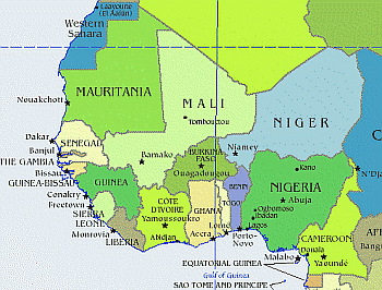
West Africa
West Africa is home to both the Achatina and Archachatina genera of snails, the latter is restricted to the West African sub-region. The coastal areas are extremely wet and humid, with up to 2,000mm of rain falling in two rainy seasons (May and June and then again in October). In the north there is considerably less rain, with only one wet period between June and September.
Being equatorial, the sun rises at about 6am every day and there is an almost constant 12/12 photoperiod that is extended to 13/11 for three months from May to July.
Ghana Rainy Seasons
South: April to June and
September and October
North: April to October
Click here to see todays
African Temperatures
West Africa
There are two main snail-harvesting seasons in each year. The major harvesting season is in September and the minor one in May/June. Incidentally the harvesting seasons coincide respectively with the major rainy season of May/June and the minor rainy season of September/October. Conversely however, the snails are less abundant during the major rainy season and more abundant during the minor rainy season.
In Ghana for instance, two species of the Achatina genus, namely Achatina achatina and Achatina fulica, and then two species of the Archachatina genus, i.e., Archachatina degneri and Archachatina marginata are known to occur (Monney, 1994). Both genera are known to be snails of the humid, tropical environment. They are found within the dense forest floors in the forest zone of Ghana and also in the humid riparian forest floors. Archachatina degneri can also be found in secondary thickets and savanna woodlands (Hodasi, 1984).
The occurrence in greater abundance of Achatina achatina, relative to Archachatina degneri is an obvious observation from both phases of study. This situation seems to be a factor related to their respective genetic make-ups, as according to Hodasi (1979). Achatina achatina is more prolific and attains sexual maturity earlier (within 2 years in the wild environment) than Archachatina degneri.
The seasonal emergence of the snails in relation to the peak rains is explainable since breakage of the snails from periods of dormancy (aestivation) is directly related to high soil moisture regime at the forest floor (Cobbinah, 1997), which is also associated with the periods of the peak annual rains. The major snail season coincides with minor peak rains of September/October whilst the minor snail season also coincides with the major peak rains of June/July. This phenomenon could be a function of the complexity of the snails' reproductive ecology, growth characteristics and annual physiological rhythms.
The vegetation structure of Ghana places the BNP into the Moist Semi-deciduous vegetation zone whereas the southern sector is within the Moist Evergreen vegetation zone, the main distinguishing character being the level of deciduousness of the standing vegetation. It may be worth noting that deciduousness could be crucial in determining the level of abundance of the giant African snails in a particular forest ecosystem. This phenomenon may be related to the abundance of litter (decaying organic matter) at the forest floor, which forms perfect substrates for detritivorous organisms such as the snails.
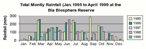
Statistics for Cameroon
Note: The weather statistics are from Cameroon with the exception of "Snail Abundance" as I am unable to find Ghana weather data.
The data is calculated/averaged based on a number of sample days from each month.
| Jan | Feb | Mar | Apr | May | Jun | Jul | Aug | Sep | Oct | Nov | Dec | |
| Day Length | 11h 55m | 12h 00m | 12h 06m | 12h 13m | 12h 18m | 12h 21m | 12h 20m | 12h 14m | 12h 08m | 12h 01m | 11h 56m | 11h 54m |
| Length Of Visible Light: | 12h 39m | 12h 42m | 12h 47m | 12h 55m | 13h 02m | 13h 07m | 13h 04m | 12h 57m | 12h 49m | 12h 43m | 12h 40m | 12h 39m |
| Mean Temperature (°C): | 24 | 25 | 29 | 28 | 28 | 25 | 25 | 26 | 25 | 27 | 25 | 28 |
| Max Temperature (°C): | 32 | 33 | 33 | 32 | 31 | 27 | 28 | 28 | 27 | 31 | 27 | 32 |
| Min Temperature (°C): | 26 | 25 | 25 | 23 | 25 | 23 | 22 | 23 | 23 | 23 | 23 | 25 |
| Dew Point (°C): | 24 | 25 | 23 | 23 | 25 | 23 | 23 | 23 | 23 | 23 | 25 | 25 |
| Temp Peak High (time): | 1500 | 1500 | 1400 | 1200 | 1200 | 1500 | 1400 | 1500 | 1500 | 1500 | 1200 | 1500 |
| Temp Peak Low (time): | 0400 | 0600 | 0400 | 0600 | 0500 | 0500 | 0500 | 0400 | 0200 | 0300 | 0100 | 0300 |
| Average rH (%): | 72 | 92 | 80 | 84 | 86 | 88 | 87 | 90 | 89 | 80 | 93 | 84 |
| Maximum rH (%): | 100 | 100 | 94 | 100 | 94 | 100 | 100 | 100 | 100 | 94 | 100 | 100 |
| Minimum rH (%): | 66 | 63 | 56 | 63 | 70 | 79 | 66 | 74 | 79 | 62 | 83 | 59 |
| rH High Peak (time): | 0300 | 0700 | 1300 | 0600 | 0400 | 0300 | 0300 | 0300 | 0200 | 0200 | 0500 | 0400 |
| rH Low Peak (time): | 1400 | 1400 | 1400 | 1200 | 1200 | 1400 | 1300 | 1500 | 1500 | 1500 | 1400 | 1500 |
| Snail Abundance (No. per Hectare) | N/A | N/A | N/A | 16 | N/A | N/A | N/A | 80 | 32 | N/A | N/A | N/A |
Ghana
The mean annual temperature in Ghana never falls below 25°C, a consequence of the low latitude of Ghana and the absence of high-altitude areas. The diurnal temperature ranges from between 5 and 9°C on the coast to between 7 and 14° C in the north.
Rainfall in Ghana generally decreases from south to north. The wettest area is the extreme southwest where annual rainfall is over 2000mm. In the extreme north the annual rainfalls is less than 1100mm. The driest area is a strip east of Sekondi-Takoradi extending eastward up to 40 km inland, where rainfall is about 750mm.
Nigeria
Nigeria has a climate, which is characterised, by relatively high temperatures throughout the year. The average annual maximum varies from 35°C in the north to 31°C in the south, the average annual minimum from 23°C in the south to 18°C in the north. On the Jos plateau and the eastern highlands, altitude makes for relatively lower temperatures, with the maximum no more than 28°C and the minimum sometimes as low as 14°C. The soil temperature is almost uniform in the country both during the day and at night.
Nigeria's has strong latitudinal zones which become progressively drier as one moves northwards from the coast. Rainfall is the key climatic variable and there is a marked difference between wet and dry seasons in most areas. By April or May the rainy season is underway in most areas south of the Niger and Benue river valleys. Farther north, rains do not commence until June or July. From December through February northwest trade winds, called harmattan, sweep across the country bringing moderate temperatures and lower humidity across the country.
The annual rainfall total decreases from over 3,800 mm at Forcados on the coast to under 650 mm at Maiduguri in the extreme north-east of the country. The length of the rainy season also shows decrease from nearly 12 months in the south to less than 5 months in the north. Rain starts in January in the south and progresses gradually across the country. The period June to September is the rainiest throughout the country. In many parts of the south, however, there is a slight break in the rains for some two to three weeks in late July and early August. No such break occurs in the northern part of the country, and rainy season continues uninterrupted for 3-6 months.
The relative humidity is also high throughout the year, more so in the south. Another effect of this high humidity in the south and that of harmattan dust in the case of the north is plenty of cloud cover. This appears to be more noticeable in the southern states at the peak of the growing season, resulting in the reduction of the rate of photosynthesis.
The variation in day-length is about 30 minutes from the north to the south.
Sierra Leone
Sierra Leone is in the lowland humid tropics. It experiences a marked rainy and dry season, with the changing position of the inter tropical convergence zone (ITCZ) being the dominant influence.
Average temperatures are between 24.6°C and 28.3°C. There are diurnal and seasonal variations of temperature. Maximum temperatures occur in March and April and minimum in July and August (mean monthly maximum of 27°C to 28°C ). Mean monthly minimum temperatures in December, January and February are 14°C to 20°C. During the remainder of the year minimum temperatures vary little from 20 °C to 23°C.
The discontinuity line between the different air masses shifting seasonally north and south, causes the invasion of northerly dry winds from the Sahara desert (harmattan) in January and the southerly wet monsoon winds in July. There is a dry season (December to March) and pre-monsoon (April to June), monsoon (July to September) and post-monsoon (October to November).
Rainfall varies between 2000 mm in the north to 4000 mm in the south. Intensity of rainfall can be very high. A maximum daily rainfall of 297 mm in Bonthe and a maximum hourly rainfall of 150 mm in Freetown have been recorded. Average rainfall far exceeds evapotranspiration; in the south and east there is an excess of precipitation over evapotranspiration for 8½ months; in the north the period drops to 7 months.
Sunshine varies substantially with the amount of cloudiness averaging 6-8 hrs per day during the rainy period.
Relative humidity is usually very high (95 -100%) especially during the rainy season. It drops to 20% during the harmattan.
São Tomé and Principe
These two islands lie almost on the equator in the Gulf of Guinea about 274 km/170 mi from the African coast. Their land area is only 960 sq km/370 sq mi. Believed to be the native home of Archachatina marginata, in particular the subspecies suturalis.
The islands have an equatorial type of climate with high temperatures and humidity throughout the year. Rainfall is moderately heavy and the climate is rather cloudy, muggy, and oppressive. The driest months are from June to September and rainfall outside these months is often heavy. The number of sunshine hours is rather low, averaging from four to six hours a day. São Tomé contains some of the largest areas of temperate climate in West Africa. Swift streams radiating down the mountains through lush forest and cropland to the sea cross both islands.
At sea level, the climate is tropical; hot and humid with average yearly temperatures of about 27°C (80°F) and little daily variation. At the interior's higher altitudes, the average yearly temperature is 20°C (68°F), and nights are generally cool. Annual rainfall varies from 500 cm on the southwestern slopes to 100 cm in the northern lowlands. The rainy season runs from October to May.
Northern and Western zone of the island of São Tomé : All year drier than the rest of the island.
Eastern zone of the island of São Tomé : Semi-humid and rain-forest sheltered beaches.
Southern zone of the island of São Tomé : Generally more humid and rainy than the rest of the island. In the South-west of both islands it is prone to rain even in the supposedly dry season.
Interior of the island of São Tomé : Almost European like temperatures for exploring the rain forest and the mountains. In general, cooler than the rest of the island. During the rainy season it is prone to rain during mid-afternoon accompanied by cold mist. The mornings and afternoons are generally sunny.